
Trail Guide · ~30 min from Pisgah Base Camp
Daniel Ridge Falls
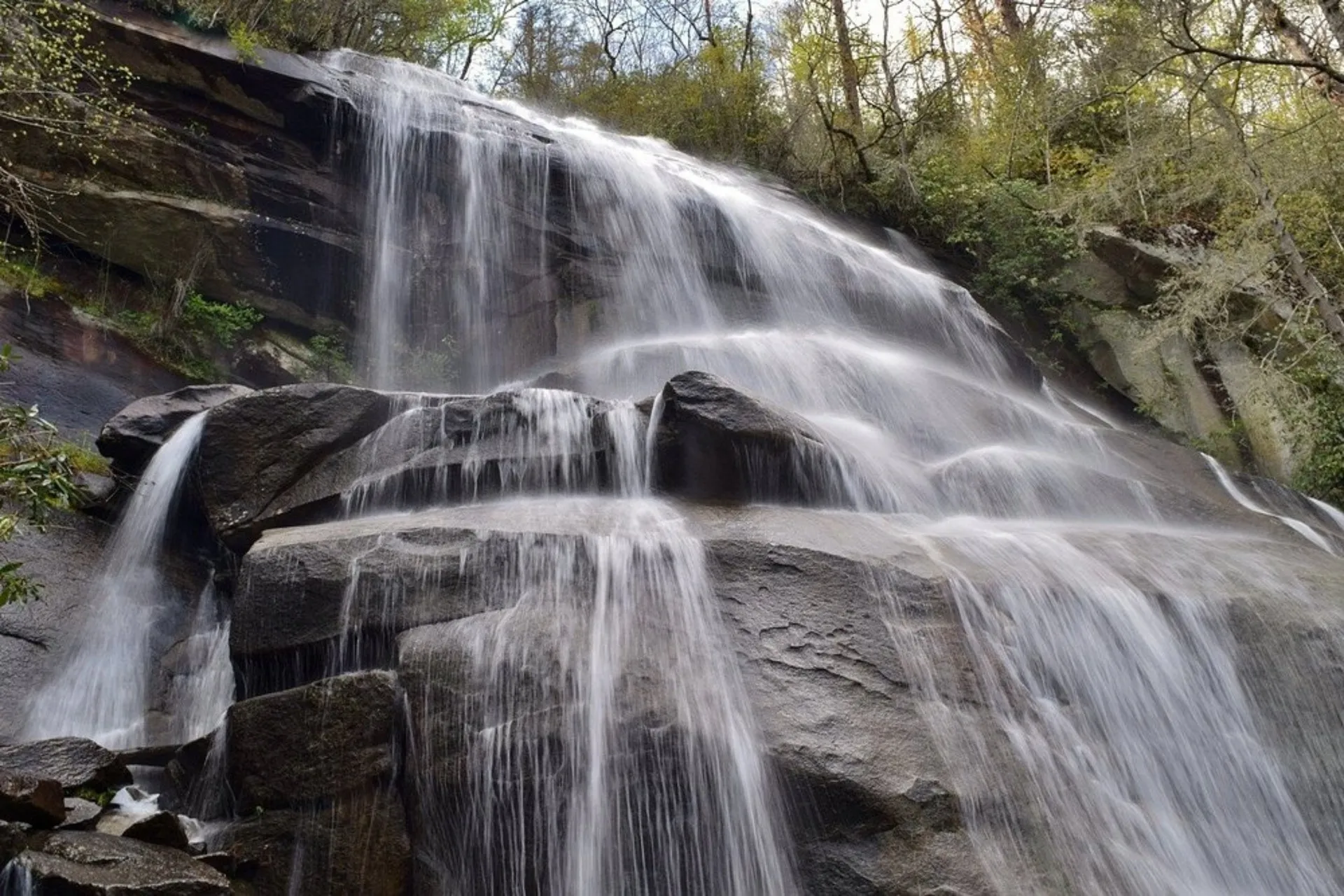
A 150-foot waterfall tucked up Forest Road 475, quieter than the marquee falls but just as tall.
Drive Time
~30 min
from the house
Height
150 ft
also called Jackson Falls
To the Falls
1 mi
round trip, easy
Full Loop
5 mi
moderate
What to Expect
A tall waterfall without the crowd
Daniel Ridge Falls is a 150-foot waterfall up Forest Road 475 in the Pisgah Ranger District, past the state fish hatchery. It goes by a few names. Some maps and older guidebooks call it Jackson Falls or Tom's Spring Falls, after Tom's Spring Branch, the creek it runs on. Same waterfall.
The falls sit less than half a mile from the parking lot on an easy old road, so you can stand under a big waterfall without much of a hike. That makes it a good pick when you want the payoff without the crowds that Looking Glass and Sliding Rock pull in right off US-276.
If you want more than the falls, the full Daniel Ridge Loop runs about 5 miles through the forest along the Davidson River headwaters, rocky and rooty in stretches with a fair bit of climbing. Plan a few hours for the whole loop, or about half an hour round trip if you only want the waterfall.
The catch is the drive. The last few miles are on Forest Road 475, which turns to gravel and one lane past the campground, so take it slow. Park in the lot by the gate and, the Forest Service is specific about this, do not block the gate itself.
The Falls
Two ways to see it
The Drop
150 ftDaniel Ridge Falls slides about 150 feet down a broad rock face, one of the taller drops in this part of the district. It is reached on an old gravel road past the gate, not right at the parking lot.
The Short Walk
1 mi round tripYou do not have to hike the whole loop. From the lot, walk past the gate, cross the bridge over the Davidson River, and follow the old road less than half a mile to the base. Easy, and good with kids.
The Full Loop
5 mi, moderateIf you want a real forest walk, the full Daniel Ridge Loop runs about 5 miles with rocky, rooty footing and a fair bit of climbing. It wanders the Davidson River headwaters and earns the waterfall at the end.
Why We Love It
A lot of waterfall for a short walk
We send people here when they have already done Looking Glass and Sliding Rock and want a tall waterfall without the parking-lot crowd. A 150-foot drop is a lot of waterfall for a half-mile walk, and most days you will share it with only a handful of people.
It also gives you a choice. Bring the family for the easy stroll to the base, or make a morning of it on the full loop through the headwaters. Either way it feels like real forest, rhododendron and creek crossings, not a pull-off by the road.
Backstory
One waterfall, three names
This waterfall answers to three names. Maps and guidebooks list it as Daniel Ridge Falls, Jackson Falls, and Tom's Spring Falls, and all three point to the same drop. The trail follows Daniel Ridge, the water runs on Tom's Spring Branch, and Jackson is the name that stuck in some of the older reference books.
That kind of triple-naming is common in this corner of Pisgah. A lot of these falls were named informally by loggers, surveyors, and early forest service crews, and different guidebooks picked up different versions over the years. We have not found a confirmed origin story for any of the three, so we will not invent one.
Know Before You Go
Short walk, gravel road
- Go early or on a weekday. Fewer people find this one than the marquee falls, but weekends still bring more traffic than a Tuesday morning.
- Park in the lot, not against the gate. There is a dedicated lot by the gated road, and the Forest Service is explicit that you should not block the gate itself.
- Drive the gravel slowly. The last stretch of Forest Road 475 is gravel and one lane in places, with a narrow bridge. Fine for a normal car in good weather, but take it easy.
- No fee. Daniel Ridge is free to hike and open year round.
- No restrooms at the trailhead. Plan ahead. The nearest facilities are back toward the fish hatchery or the ranger station.
- Dogs welcome. Leashed dogs are fine on the trail. Watch their footing on the wet rock near the falls.
- Cell service is spotty. Download an offline map before you leave the house.
Safety First
Real risks at the falls
- Rock near and above the falls stays wet and slick. Enjoy it from the base and never climb the face or scramble to the top.
- The full loop is rocky and rooty with real elevation gain. Wear real shoes and watch your footing, especially when it is wet.
- Creek crossings and the river can rise fast after rain. Do not cross water that looks high or pushy.
- Forest Road 475 is gravel and narrow past the campground. Drive slowly, be ready to yield, and think twice in ice or after a storm.
- This is black bear country. Pack out all food and trash, and tell someone your plan since cell coverage is unreliable.
Directions
From Pisgah Base Camp to the trailhead
Daniel Ridge sits up Forest Road 475 in the Pisgah Ranger District, past the state fish hatchery. Park in the lot by the gated road, walk past the gate and over the Davidson River bridge, and the falls are about half a mile in on the old road.
- 1 From the house, head toward the Pisgah Forest entrance and the US-276 corridor.
- 2 Take US-276 north about 5 miles into Pisgah National Forest.
- 3 Turn left onto Forest Road 475 at the sign for the Pisgah Center for Wildlife Education and the fish hatchery.
- 4 Stay on FR 475 for about 4 miles, past the hatchery and the Cove Creek group camp. The pavement gives way to gravel.
- 5 Just after the one-lane bridge over the Davidson River, the parking lot is on the right. Park in the lot, keep the gate clear, then walk past the gate about half a mile to the falls.
Forest Road 475 turns to gravel and one lane past the campground, and forest roads here can close for weather or repairs. Check current Pisgah status before you go, especially in winter or after heavy rain.
Keep Exploring
Other places guests love
From the Blog
Is Pisgah Forest Worth Visiting in Winter? What's Open, What's Not, and How to Plan It
Winter in Pisgah Forest trades the crowds for frozen waterfalls and quiet trailheads. Here is what stays open, what closes, and how to plan a cold-weather trip from the house.
Read the postWhat Do You Do Near Pisgah Forest When It Rains? A Plan for the Wet Day
Rain in Pisgah is not a lost day. The waterfalls run biggest, the trails empty out, and Brevard has a dry afternoon in it. Here is how to plan the wet day from the house.
Read the postYou Already Know the Trip You Want
An early start. A big day outside. Then a hot shower and a quiet night when you get back.
That's the trip. You just need the right place to do it from.
We'll help you sort out the plan before you get here. You bring the bikes, boots, rods, and the dog.